Frio County
| County in de Verenigde Staten | |||
|---|---|---|---|
| |||
| Situering | |||
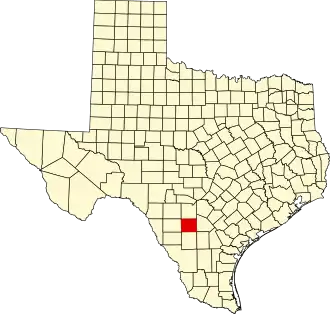
| Staat | Texas | ||
| Coördinaten | 28°51'36"NB, 99°6'36"WL | ||
| Algemeen | |||
| Oppervlakte | 2.938 km² | ||
| - land | 2.935 km² | ||
| - water | 3 km² | ||
| Inwoners (2000) |
16.252 (6 inw./km²) | ||
| Overig | |||
| Zetel | Pearsall | ||
| FIPS-code | 48163 | ||
| Opgericht | 1858 | ||
| Website | www | ||
| Foto's | |||

| |||
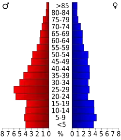 Bevolkingspiramide Frio County | |||
| Statistieken volkstelling Frio County | |||
| |||
Frio County is een van de 254 county's in de Amerikaanse staat Texas.
De county heeft een landoppervlakte van 2.935 km² en telt 16.252 inwoners (volkstelling 2000). De hoofdplaats is Pearsall.
Bevolkingsontwikkeling
| Jaar | Inwoners | % ± | |
|---|---|---|---|
| 1900 | 4.200 | — | |
| 1910 | 8.895 | 111,8% | |
| 1920 | 9.296 | 4,5% | |
| 1930 | 9.411 | 1,2% | |
| 1940 | 9.207 | −2,2% | |
| 1950 | 10.357 | 12,5% | |
| 1960 | 10.112 | −2,4% | |
| 1970 | 11.159 | 10,4% | |
| 1980 | 13.785 | 23,5% | |
| 1990 | 13.472 | −2,3% | |
| 2000 | 16.252 | 20,6% | |
| Bron: (en) Historical Decennial Census Population | |||