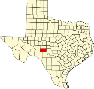
Sutton County
| County in de Verenigde Staten | |||
|---|---|---|---|
| |||
| Situering | |||
| Staat | Texas | ||
| Coördinaten | 30°30'0"NB, 100°32'24"WL | ||
| Algemeen | |||
| Oppervlakte | 3.767 km² | ||
| - land | 3.765 km² | ||
| - water | 2 km² | ||
| Inwoners (2000) |
4.077 (1 inw./km²) | ||
| Overig | |||
| Zetel | Sonora | ||
| FIPS-code | 48435 | ||
| Opgericht | 1887 | ||
| Website | www | ||
| Foto's | |||

| |||
 Bevolkingspiramide Sutton County | |||
| Statistieken volkstelling Sutton County | |||
| |||
Sutton County is een van de 254 county's in de Amerikaanse staat Texas.
De county heeft een landoppervlakte van 3.765 km² en telt 4.077 inwoners (volkstelling 2000). De hoofdplaats is Sonora.
Bevolkingsontwikkeling
| Jaar | Inwoners | % ± | |
|---|---|---|---|
| 1900 | 1.727 | — | |
| 1910 | 1.569 | −9,1% | |
| 1920 | 1.598 | 1,8% | |
| 1930 | 2.807 | 75,7% | |
| 1940 | 3.977 | 41,7% | |
| 1950 | 3.746 | −5,8% | |
| 1960 | 3.738 | −0,2% | |
| 1970 | 3.175 | −15,1% | |
| 1980 | 5.130 | 61,6% | |
| 1990 | 4.135 | −19,4% | |
| 2000 | 4.077 | −1,4% | |
| Bron: (en) Historical Decennial Census Population | |||