Potter County (Texas)
| County in de Verenigde Staten | |||
|---|---|---|---|
| |||
| Situering | |||
| Staat | Texas | ||
| Coördinaten | 35°24'0"NB, 101°53'24"WL | ||
| Algemeen | |||
| Oppervlakte | 2.388 km² | ||
| - land | 2.355 km² | ||
| - water | 33 km² | ||
| Inwoners (2000) |
113.546 (48 inw./km²) | ||
| Overig | |||
| Zetel | Amarillo | ||
| FIPS-code | 48375 | ||
| Opgericht | 1876 | ||
| Website | www | ||
| Foto's | |||

| |||
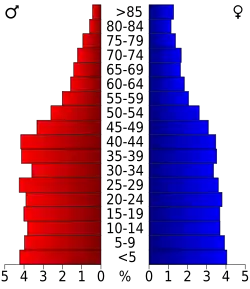 Bevolkingspiramide Potter County | |||
| Statistieken volkstelling Potter County | |||
| |||
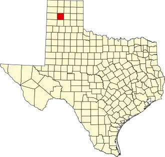
Potter County is een van de 254 county's in de Amerikaanse staat Texas.
De county heeft een landoppervlakte van 2.355 km² en telt 113.546 inwoners (volkstelling 2000). De hoofdplaats is Amarillo.
Bevolkingsontwikkeling
| Jaar | Inwoners | % ± | |
|---|---|---|---|
| 1900 | 1.820 | — | |
| 1910 | 12.424 | 582,6% | |
| 1920 | 16.710 | 34,5% | |
| 1930 | 46.080 | 175,8% | |
| 1940 | 54.265 | 17,8% | |
| 1950 | 73.366 | 35,2% | |
| 1960 | 115.580 | 57,5% | |
| 1970 | 90.511 | −21,7% | |
| 1980 | 98.637 | 9,0% | |
| 1990 | 97.874 | −0,8% | |
| 2000 | 113.546 | 16,0% | |
| Bron: (en) Historical Decennial Census Population | |||
Belangrijke snelwegen
- Interstate 27
- Interstate 40
- U.S. Highway 60
- U.S. Highway 87
- U.S. Highway 287
- State Highway 136
Plaatsen in de omgeving
- Moore County (north)
- Carson County (east)
- Randall County (south)
- Oldham County (west)