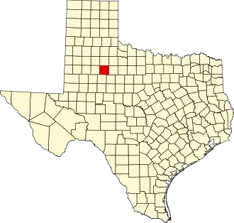
Kent County (Texas)
| County in de Verenigde Staten | |||
|---|---|---|---|
| |||
| Situering | |||
| Staat | Texas | ||
| Coördinaten | 33°11'24"NB, 100°46'12"WL | ||
| Algemeen | |||
| Oppervlakte | 2.339 km² | ||
| - land | 2.337 km² | ||
| - water | 2 km² | ||
| Inwoners (2000) |
859 (0 inw./km²) | ||
| Overig | |||
| Zetel | Jayton | ||
| FIPS-code | 48263 | ||
| Opgericht | 1876 | ||
| Website | www | ||
| Foto's | |||

| |||
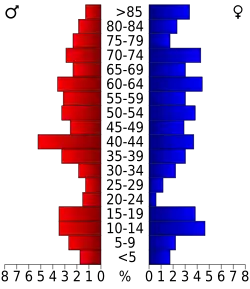 Bevolkingspiramide Kent County | |||
| Statistieken volkstelling Kent County | |||
| |||
Kent County is een van de 254 county's in de Amerikaanse staat Texas.
De county heeft een landoppervlakte van 2.337 km² en telt 859 inwoners (volkstelling 2000). De hoofdplaats is Jayton.
Bevolkingsontwikkeling
| Jaar | Inwoners | % ± | |
|---|---|---|---|
| 1900 | 899 | — | |
| 1910 | 2.655 | 195,3% | |
| 1920 | 3.335 | 25,6% | |
| 1930 | 3.851 | 15,5% | |
| 1940 | 3.413 | −11,4% | |
| 1950 | 2.249 | −34,1% | |
| 1960 | 1.727 | −23,2% | |
| 1970 | 1.434 | −17,0% | |
| 1980 | 1.145 | −20,2% | |
| 1990 | 1.010 | −11,8% | |
| 2000 | 859 | −15,0% | |
| Bron: (en) Historical Decennial Census Population | |||