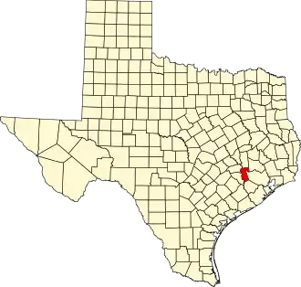
Waller County
| County in de Verenigde Staten | |||
|---|---|---|---|
| |||
| Situering | |||
| Staat | Texas | ||
| Coördinaten | 30°0'36"NB, 95°58'48"WL | ||
| Algemeen | |||
| Oppervlakte | 1.343 km² | ||
| - land | 1.330 km² | ||
| - water | 13 km² | ||
| Inwoners (2000) |
32.663 (25 inw./km²) | ||
| Overig | |||
| Zetel | Hempstead | ||
| FIPS-code | 48473 | ||
| Opgericht | 1873 | ||
| Website | www | ||
| Foto's | |||

| |||
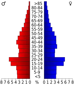 Bevolkingspiramide Waller County | |||
| Statistieken volkstelling Waller County | |||
| |||
Waller County is een van de 254 county's in de Amerikaanse staat Texas.
De county heeft een landoppervlakte van 1.330 km² en telt 32.663 inwoners (volkstelling 2000). De hoofdplaats is Hempstead.
Bevolkingsontwikkeling
| Jaar | Inwoners | % ± | |
|---|---|---|---|
| 1900 | 14.246 | — | |
| 1910 | 12.138 | −14,8% | |
| 1920 | 10.292 | −15,2% | |
| 1930 | 10.014 | −2,7% | |
| 1940 | 10.280 | 2,7% | |
| 1950 | 11.961 | 16,4% | |
| 1960 | 12.071 | 0,9% | |
| 1970 | 14.285 | 18,3% | |
| 1980 | 19.798 | 38,6% | |
| 1990 | 23.390 | 18,1% | |
| 2000 | 32.663 | 39,6% | |
| Bron: (en) Historical Decennial Census Population | |||