Calhoun County (Texas)
| County in de Verenigde Staten | |||
|---|---|---|---|
| |||
| Situering | |||
| Staat | Texas | ||
| Coördinaten | 28°26'24"NB, 96°36'36"WL | ||
| Algemeen | |||
| Oppervlakte | 2.673 km² | ||
| - land | 1.327 km² | ||
| - water | 1.346 km² | ||
| Inwoners (2000) |
20.647 (16 inw./km²) | ||
| Overig | |||
| Zetel | Port Lavaca | ||
| FIPS-code | 48057 | ||
| Opgericht | 1846 | ||
| Website | www | ||
| Foto's | |||

| |||
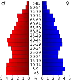 Bevolkingspiramide Calhoun County | |||
| Statistieken volkstelling Calhoun County | |||
| |||
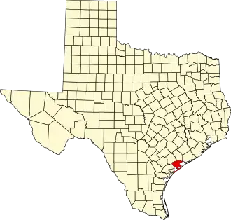
Calhoun County is een van de 254 county's in de Amerikaanse staat Texas.
De county heeft een landoppervlakte van 1.327 km² en telt 20.647 inwoners (volkstelling 2000). De hoofdplaats is Port Lavaca.
De kust van Calhoun County wordt gevormd door de Matagordabaai.
Bevolkingsontwikkeling
| Jaar | Inwoners | % ± | |
|---|---|---|---|
| 1900 | 2.395 | — | |
| 1910 | 3.635 | 51,8% | |
| 1920 | 4.700 | 29,3% | |
| 1930 | 5.385 | 14,6% | |
| 1940 | 5.911 | 9,8% | |
| 1950 | 9.222 | 56,0% | |
| 1960 | 16.592 | 79,9% | |
| 1970 | 17.831 | 7,5% | |
| 1980 | 19.574 | 9,8% | |
| 1990 | 19.053 | −2,7% | |
| 2000 | 20.647 | 8,4% | |
| Bron: (en) Historical Decennial Census Population | |||