Dallam County
| County in de Verenigde Staten | |||
|---|---|---|---|

| |||
| Situering | |||
| Staat | Texas | ||
| Coördinaten | 36°17'24"NB, 102°35'24"WL | ||
| Algemeen | |||
| Oppervlakte | 3.898 km² | ||
| - land | 3.897 km² | ||
| - water | 1 km² | ||
| Inwoners (2000) |
6.222 (2 inw./km²) | ||
| Overig | |||
| Zetel | Dalhart | ||
| FIPS-code | 48111 | ||
| Opgericht | 1876 | ||
| Website | www | ||
| Foto's | |||

| |||
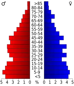 Bevolkingspiramide Dallam County | |||
| Statistieken volkstelling Dallam County | |||
| |||
Dallam County is een van de 254 county's in de Amerikaanse staat Texas.
De county heeft een landoppervlakte van 3.897 km² en telt 6.222 inwoners (volkstelling 2000). De hoofdplaats is Dalhart.
Bevolkingsontwikkeling
| Jaar | Inwoners | % ± | |
|---|---|---|---|
| 1900 | 146 | — | |
| 1910 | 4.001 | 2.640,4% | |
| 1920 | 4.528 | 13,2% | |
| 1930 | 7.830 | 72,9% | |
| 1940 | 6.494 | −17,1% | |
| 1950 | 7.640 | 17,6% | |
| 1960 | 6.302 | −17,5% | |
| 1970 | 6.012 | −4,6% | |
| 1980 | 6.531 | 8,6% | |
| 1990 | 5.461 | −16,4% | |
| 2000 | 6.222 | 13,9% | |
| Bron: (en) Historical Decennial Census Population | |||