Ector County
| County in de Verenigde Staten | |||
|---|---|---|---|

| |||
| Situering | |||
| Staat | Texas | ||
| Coördinaten | 31°52'12"NB, 102°32'24"WL | ||
| Algemeen | |||
| Oppervlakte | 2.336 km² | ||
| - land | 2.334 km² | ||
| - water | 2 km² | ||
| Inwoners (2000) |
121.123 (52 inw./km²) | ||
| Overig | |||
| Zetel | Odessa | ||
| FIPS-code | 48135 | ||
| Opgericht | 1887 | ||
| Website | www | ||
| Foto's | |||
_DSCN1270.JPG)
| |||
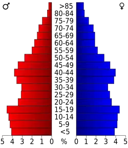 Bevolkingspiramide Ector County | |||
| Statistieken volkstelling Ector County | |||
| |||
Ector County is een van de 254 county's in de Amerikaanse staat Texas.
De county heeft een landoppervlakte van 2.334 km² en telt 121.123 inwoners (volkstelling 2000). De hoofdplaats is Odessa.
Bevolkingsontwikkeling
| Jaar | Inwoners | % ± | |
|---|---|---|---|
| 1900 | 381 | — | |
| 1910 | 1.178 | 209,2% | |
| 1920 | 760 | −35,5% | |
| 1930 | 3.958 | 420,8% | |
| 1940 | 15.051 | 280,3% | |
| 1950 | 42.102 | 179,7% | |
| 1960 | 90.995 | 116,1% | |
| 1970 | 91.805 | 0,9% | |
| 1980 | 115.374 | 25,7% | |
| 1990 | 118.934 | 3,1% | |
| 2000 | 121.123 | 1,8% | |
| Bron: (en) Historical Decennial Census Population | |||
