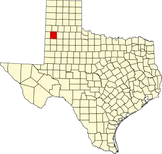
Lamb County
| County in de Verenigde Staten | |||
|---|---|---|---|
| |||
| Situering | |||
| Staat | Texas | ||
| Coördinaten | 34°4'12"NB, 102°21'0"WL | ||
| Algemeen | |||
| Oppervlakte | 2.636 km² | ||
| - land | 2.632 km² | ||
| - water | 4 km² | ||
| Inwoners (2000) |
14.709 (6 inw./km²) | ||
| Overig | |||
| Zetel | Littlefield | ||
| FIPS-code | 48279 | ||
| Opgericht | 1876 | ||
| Website | co | ||
| Foto's | |||

| |||
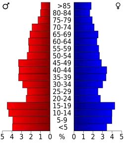 Bevolkingspiramide Lamb County | |||
| Statistieken volkstelling Lamb County | |||
| |||
Lamb County is een van de 254 county's in de Amerikaanse staat Texas.
De county heeft een landoppervlakte van 2.632 km² en telt 14.709 inwoners (volkstelling 2000). De hoofdplaats is Littlefield.
Bevolkingsontwikkeling
| Jaar | Inwoners | % ± | |
|---|---|---|---|
| 1900 | 31 | — | |
| 1910 | 540 | 1.641,9% | |
| 1920 | 1.175 | 117,6% | |
| 1930 | 17.452 | 1.385,3% | |
| 1940 | 17.606 | 0,9% | |
| 1950 | 20.015 | 13,7% | |
| 1960 | 21.896 | 9,4% | |
| 1970 | 17.770 | −18,8% | |
| 1980 | 18.669 | 5,1% | |
| 1990 | 15.072 | −19,3% | |
| 2000 | 14.709 | −2,4% | |
| Bron: (en) Historical Decennial Census Population | |||