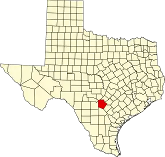
Bexar County
| County in de Verenigde Staten | |||
|---|---|---|---|
| |||
| Situering | |||
| Staat | Texas | ||
| Coördinaten | 29°27'0"NB, 98°31'12"WL | ||
| Algemeen | |||
| Oppervlakte | 3.254 km² | ||
| - land | 3.229 km² | ||
| - water | 25 km² | ||
| Inwoners (2000) |
1.392.931 (431 inw./km²) | ||
| Overig | |||
| Zetel | San Antonio | ||
| FIPS-code | 48029 | ||
| Opgericht | 1836 | ||
| Website | www | ||
| Foto's | |||

| |||
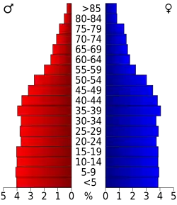 Bevolkingspiramide Bexar County | |||
| Statistieken volkstelling Bexar County | |||
| |||
Bexar County is een van de 254 county's in de Amerikaanse staat Texas.
De county heeft een landoppervlakte van 3.229 km² en telt 1.392.931 inwoners (volkstelling 2000). De hoofdplaats is San Antonio.
Bevolkingsontwikkeling
| Jaar | Inwoners | % ± | |
|---|---|---|---|
| 1900 | 69.422 | — | |
| 1910 | 119.676 | 72,4% | |
| 1920 | 202.096 | 68,9% | |
| 1930 | 292.533 | 44,7% | |
| 1940 | 338.176 | 15,6% | |
| 1950 | 500.460 | 48,0% | |
| 1960 | 687.151 | 37,3% | |
| 1970 | 830.460 | 20,9% | |
| 1980 | 988.800 | 19,1% | |
| 1990 | 1.185.394 | 19,9% | |
| 2000 | 1.392.931 | 17,5% | |
| Bron: (en) Historical Decennial Census Population | |||