Pleasants County
| County in de Verenigde Staten | |||
|---|---|---|---|
| |||
| Situering | |||
| Staat | West Virginia | ||
| Tijdzone | Eastern Standard Time (UTC−5) | ||
| Coördinaten | 39°22'12"NB, 81°9'36"WL | ||
| Algemeen | |||
| Oppervlakte | 349 km² | ||
| - land | 339 km² | ||
| - water | 10 km² | ||
| Inwoners (2000) |
7.514 (22 inw./km²) | ||
| Overig | |||
| Zetel | St. Marys | ||
| FIPS-code | 54073 | ||
| Opgericht | 1851 | ||
| Website | www | ||
| Foto's | |||

| |||
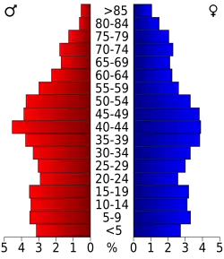 Bevolkingspiramide Pleasants County | |||
| Statistieken volkstelling Pleasants County | |||
| |||
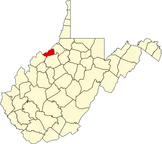
Pleasants County is een van de 55 county's in de Amerikaanse staat West Virginia.
De county heeft een landoppervlakte van 339 km² en telt 7.514 inwoners (volkstelling 2000). De hoofdplaats is St. Marys.
Bevolkingsontwikkeling
| Jaar | Inwoners | % ± | |
|---|---|---|---|
| 1900 | 9.345 | — | |
| 1910 | 8.074 | −13,6% | |
| 1920 | 7.379 | −8,6% | |
| 1930 | 6.545 | −11,3% | |
| 1940 | 6.692 | 2,2% | |
| 1950 | 6.369 | −4,8% | |
| 1960 | 7.124 | 11,9% | |
| 1970 | 7.274 | 2,1% | |
| 1980 | 8.236 | 13,2% | |
| 1990 | 7.546 | −8,4% | |
| 2000 | 7.514 | −0,4% | |
| Bron: (en) Historical Decennial Census Population | |||