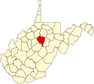
Lewis County (West Virginia)
| County in de Verenigde Staten | |||
|---|---|---|---|
| |||
| Situering | |||
| Staat | West Virginia | ||
| Tijdzone | Eastern Standard Time (UTC−5) | ||
| Coördinaten | 39°0'0"NB, 80°30'36"WL | ||
| Algemeen | |||
| Oppervlakte | 1.010 km² | ||
| - land | 990 km² | ||
| - water | 20 km² | ||
| Inwoners (2000) |
16.919 (17 inw./km²) | ||
| Overig | |||
| Zetel | Weston | ||
| FIPS-code | 54041 | ||
| Opgericht | 1816 | ||
| Website | www | ||
| Foto's | |||

| |||
 Bevolkingspiramide Lewis County | |||
| Statistieken volkstelling Lewis County | |||
| |||
Lewis County is een van de 55 county's in de Amerikaanse staat West Virginia.
De county heeft een landoppervlakte van 990 km² en telt 16.919 inwoners (volkstelling 2000). De hoofdplaats is Weston.
Bevolkingsontwikkeling
| Jaar | Inwoners | % ± | |
|---|---|---|---|
| 1900 | 16.980 | — | |
| 1910 | 18.281 | 7,7% | |
| 1920 | 20.455 | 11,9% | |
| 1930 | 21.794 | 6,5% | |
| 1940 | 22.271 | 2,2% | |
| 1950 | 21.074 | −5,4% | |
| 1960 | 19.711 | −6,5% | |
| 1970 | 17.847 | −9,5% | |
| 1980 | 18.813 | 5,4% | |
| 1990 | 17.223 | −8,5% | |
| 2000 | 16.919 | −1,8% | |
| Bron: (en) Historical Decennial Census Population | |||