Harrison County (West Virginia)
| County in de Verenigde Staten | |||
|---|---|---|---|
| |||
| Situering | |||
| Staat | West Virginia | ||
| Tijdzone | Eastern Standard Time (UTC−5) | ||
| Coördinaten | 39°17'24"NB, 80°22'48"WL | ||
| Algemeen | |||
| Oppervlakte | 1.079 km² | ||
| - land | 1.078 km² | ||
| - water | 1 km² | ||
| Inwoners (2000) |
68.652 (64 inw./km²) | ||
| Overig | |||
| Zetel | Clarksburg | ||
| FIPS-code | 54033 | ||
| Opgericht | 1784 | ||
| Website | www | ||
| Foto's | |||

| |||
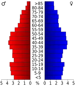 Bevolkingspiramide Harrison County | |||
| Statistieken volkstelling Harrison County | |||
| |||
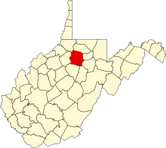
Harrison County is een van de 55 county's in de Amerikaanse staat West Virginia.
De county heeft een landoppervlakte van 1.078 km² en telt 68.652 inwoners (volkstelling 2000). De hoofdplaats is Clarksburg.
Bevolkingsontwikkeling
| Jaar | Inwoners | % ± | |
|---|---|---|---|
| 1900 | 27.690 | — | |
| 1910 | 48.381 | 74,7% | |
| 1920 | 74.793 | 54,6% | |
| 1930 | 78.567 | 5,0% | |
| 1940 | 82.911 | 5,5% | |
| 1950 | 85.296 | 2,9% | |
| 1960 | 77.856 | −8,7% | |
| 1970 | 73.028 | −6,2% | |
| 1980 | 77.710 | 6,4% | |
| 1990 | 69.371 | −10,7% | |
| 2000 | 68.652 | −1,0% | |
| Bron: (en) Historical Decennial Census Population | |||