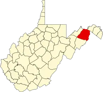
Hampshire County (West Virginia)
| County in de Verenigde Staten | |||
|---|---|---|---|
| |||
| Situering | |||
| Staat | West Virginia | ||
| Tijdzone | Eastern Standard Time (UTC−5) | ||
| Coördinaten | 39°18'36"NB, 78°36'36"WL | ||
| Algemeen | |||
| Oppervlakte | 1.670 km² | ||
| - land | 1.662 km² | ||
| - water | 8 km² | ||
| Inwoners (2000) |
20.203 (12 inw./km²) | ||
| Overig | |||
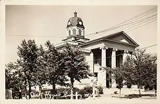
| Zetel | Romney | ||
| FIPS-code | 54027 | ||
| Opgericht | 1753 | ||
| Website | www | ||
| Foto's | |||
| |||
 Bevolkingspiramide Hampshire County | |||
| Statistieken volkstelling Hampshire County | |||
| |||
Hampshire County is een van de 55 county's in de Amerikaanse staat West Virginia.
De county heeft een landoppervlakte van 1.662 km² en telt 20.203 inwoners (volkstelling 2000). De hoofdplaats is Romney.
Bevolkingsontwikkeling
| Jaar | Inwoners | % ± | |
|---|---|---|---|
| 1900 | 11.806 | — | |
| 1910 | 11.694 | −0,9% | |
| 1920 | 11.713 | 0,2% | |
| 1930 | 11.836 | 1,1% | |
| 1940 | 12.974 | 9,6% | |
| 1950 | 12.577 | −3,1% | |
| 1960 | 11.705 | −6,9% | |
| 1970 | 11.710 | 0,0% | |
| 1980 | 14.867 | 27,0% | |
| 1990 | 16.498 | 11,0% | |
| 2000 | 20.203 | 22,5% | |
| Bron: (en) Historical Decennial Census Population | |||
De hoofdstad van het graafschap is Romney.