Calhoun County (West Virginia)
| County in de Verenigde Staten | |||
|---|---|---|---|

| |||
| Situering | |||
| Staat | West Virginia | ||
| Tijdzone | Eastern Standard Time (UTC−5) | ||
| Coördinaten | 38°50'24"NB, 81°7'12"WL | ||
| Algemeen | |||
| Oppervlakte | 727 km² | ||
| - land | 727 km² | ||
| - water | 0 km² | ||
| Inwoners (2000) |
7.582 (10 inw./km²) | ||
| Overig | |||
| Zetel | Grantsville | ||
| FIPS-code | 54013 | ||
| Opgericht | 1856 | ||
| Website | www | ||
| Foto's | |||
| |||
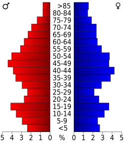 Bevolkingspiramide Calhoun County | |||
| Statistieken volkstelling Calhoun County | |||
| |||
Calhoun County is een van de 55 county's in de Amerikaanse staat West Virginia.
De county heeft een landoppervlakte van 727 km² en telt 7.582 inwoners (volkstelling 2000). De hoofdplaats is Grantsville.
Bevolkingsontwikkeling
| Jaar | Inwoners | % ± | |
|---|---|---|---|
| 1900 | 10.266 | — | |
| 1910 | 11.258 | 9,7% | |
| 1920 | 10.268 | −8,8% | |
| 1930 | 10.866 | 5,8% | |
| 1940 | 12.455 | 14,6% | |
| 1950 | 10.259 | −17,6% | |
| 1960 | 7.948 | −22,5% | |
| 1970 | 7.046 | −11,3% | |
| 1980 | 8.250 | 17,1% | |
| 1990 | 7.885 | −4,4% | |
| 2000 | 7.582 | −3,8% | |
| Bron: (en) Historical Decennial Census Population | |||
Zie de categorie Calhoun County, West Virginia van Wikimedia Commons voor mediabestanden over dit onderwerp.