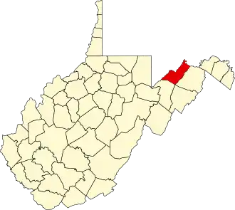
Mineral County (West Virginia)
| County in de Verenigde Staten | |||
|---|---|---|---|
| |||
| Situering | |||
| Staat | West Virginia | ||
| Tijdzone | Eastern Standard Time (UTC−5) | ||
| Coördinaten | 39°25'12"NB, 78°56'24"WL | ||
| Algemeen | |||
| Oppervlakte | 853 km² | ||
| - land | 849 km² | ||
| - water | 4 km² | ||
| Inwoners (2000) |
27.078 (32 inw./km²) | ||
| Overig | |||
| Zetel | Keyser | ||
| FIPS-code | 54057 | ||
| Opgericht | 1866 | ||
| Website | www | ||
| Foto's | |||

| |||
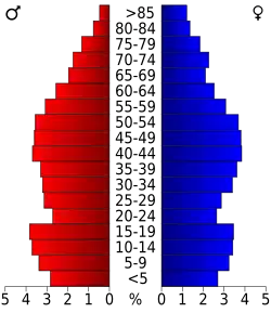 Bevolkingspiramide Mineral County | |||
| Statistieken volkstelling Mineral County | |||
| |||
Mineral County is een van de 55 county's in de Amerikaanse staat West Virginia.
De county heeft een landoppervlakte van 849 km² en telt 27.078 inwoners (volkstelling 2000). De hoofdplaats is Keyser.
Bevolkingsontwikkeling
| Jaar | Inwoners | % ± | |
|---|---|---|---|
| 1900 | 12.883 | — | |
| 1910 | 16.674 | 29,4% | |
| 1920 | 19.849 | 19,0% | |
| 1930 | 20.084 | 1,2% | |
| 1940 | 22.215 | 10,6% | |
| 1950 | 22.333 | 0,5% | |
| 1960 | 22.354 | 0,1% | |
| 1970 | 23.109 | 3,4% | |
| 1980 | 27.234 | 17,9% | |
| 1990 | 26.697 | −2,0% | |
| 2000 | 27.078 | 1,4% | |
| Bron: (en) Historical Decennial Census Population | |||