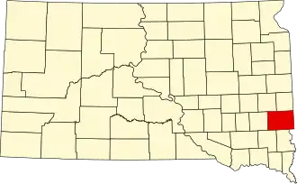
Minnehaha County
| County in de Verenigde Staten | |||
|---|---|---|---|
| |||
| Situering | |||
| Staat | South Dakota | ||
| Coördinaten | 43°40'48"NB, 96°47'24"WL | ||
| Algemeen | |||
| Oppervlakte | 2.107 km² | ||
| - land | 2.097 km² | ||
| - water | 10 km² | ||
| Inwoners (2000) |
148.281 (71 inw./km²) | ||
| Overig | |||
| Zetel | Sioux Falls | ||
| FIPS-code | 46099 | ||
| Opgericht | 1830 | ||
| Website | www | ||
| Foto's | |||

| |||
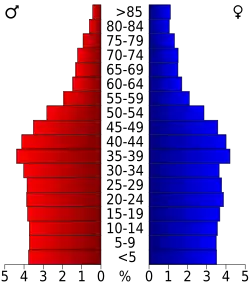 Bevolkingspiramide Minnehaha County | |||
| Statistieken volkstelling Minnehaha County | |||
| |||
Minnehaha County is een van de 66 county's in de Amerikaanse staat South Dakota.
De county heeft een landoppervlakte van 2.097 km² en telt 148.281 inwoners (volkstelling 2000). De hoofdplaats is Sioux Falls.
Bevolkingsontwikkeling
| Jaar | Inwoners | % ± | |
|---|---|---|---|
| 1900 | 23.926 | — | |
| 1910 | 29.631 | 23,8% | |
| 1920 | 42.490 | 43,4% | |
| 1930 | 50.872 | 19,7% | |
| 1940 | 57.697 | 13,4% | |
| 1950 | 70.910 | 22,9% | |
| 1960 | 86.575 | 22,1% | |
| 1970 | 95.209 | 10,0% | |
| 1980 | 109.435 | 14,9% | |
| 1990 | 123.809 | 13,1% | |
| 2000 | 148.281 | 19,8% | |
| Bron: (en) Historical Decennial Census Population | |||