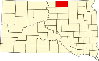
McPherson County (South Dakota)
| County in de Verenigde Staten | |||
|---|---|---|---|
| |||
| Situering | |||
| Staat | South Dakota | ||
| Coördinaten | 45°46'12"NB, 99°13'12"WL | ||
| Algemeen | |||
| Oppervlakte | 2.984 km² | ||
| - land | 2.945 km² | ||
| - water | 39 km² | ||
| Inwoners (2000) |
2.904 (1 inw./km²) | ||
| Overig | |||
| Zetel | Leola | ||
| FIPS-code | 46089 | ||
| Website | mcpherson | ||
| Foto's | |||

| |||
 Bevolkingspiramide McPherson County | |||
| Statistieken volkstelling McPherson County | |||
| |||
McPherson County is een van de 66 county's in de Amerikaanse staat South Dakota.
De county heeft een landoppervlakte van 2.945 km² en telt 2.904 inwoners (volkstelling 2000). De hoofdplaats is Leola.
Bevolkingsontwikkeling
| Jaar | Inwoners | % ± | |
|---|---|---|---|
| 1900 | 6.327 | — | |
| 1910 | 6.791 | 7,3% | |
| 1920 | 7.705 | 13,5% | |
| 1930 | 8.774 | 13,9% | |
| 1940 | 8.353 | −4,8% | |
| 1950 | 7.071 | −15,3% | |
| 1960 | 5.821 | −17,7% | |
| 1970 | 5.022 | −13,7% | |
| 1980 | 4.027 | −19,8% | |
| 1990 | 3.228 | −19,8% | |
| 2000 | 2.904 | −10,0% | |
| Bron: (en) Historical Decennial Census Population | |||