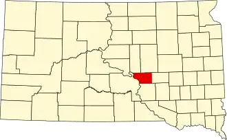
Buffalo County (South Dakota)
| County in de Verenigde Staten | |||
|---|---|---|---|
| |||
| Situering | |||
| Staat | South Dakota | ||
| Coördinaten | 44°4'48"NB, 99°12'0"WL | ||
| Algemeen | |||
| Oppervlakte | 1.263 km² | ||
| - land | 1.219 km² | ||
| - water | 44 km² | ||
| Inwoners (2000) |
2.032 (2 inw./km²) | ||
| Overig | |||
| Zetel | Gannvalley | ||
| FIPS-code | 46017 | ||
| Website | gannvalley | ||
| Foto's | |||

| |||
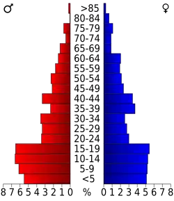 Bevolkingspiramide Buffalo County | |||
| Statistieken volkstelling Buffalo County | |||
| |||
Buffalo County is een van de 66 county's in de Amerikaanse staat South Dakota.
De county heeft een landoppervlakte van 1.219 km² en telt 2.032 inwoners (volkstelling 2000). De hoofdplaats is Gannvalley.
Bevolkingsontwikkeling
| Jaar | Inwoners | % ± | |
|---|---|---|---|
| 1900 | 1.790 | — | |
| 1910 | 1.589 | −11,2% | |
| 1920 | 1.715 | 7,9% | |
| 1930 | 1.931 | 12,6% | |
| 1940 | 1.853 | −4,0% | |
| 1950 | 1.615 | −12,8% | |
| 1960 | 1.547 | −4,2% | |
| 1970 | 1.739 | 12,4% | |
| 1980 | 1.795 | 3,2% | |
| 1990 | 1.759 | −2,0% | |
| 2000 | 2.032 | 15,5% | |
| Bron: (en) Historical Decennial Census Population | |||