Hughes County (South Dakota)
| County in de Verenigde Staten | |||
|---|---|---|---|
| |||
| Situering | |||
| Staat | South Dakota | ||
| Coördinaten | 44°23'24"NB, 99°59'24"WL | ||
| Algemeen | |||
| Oppervlakte | 2.073 km² | ||
| - land | 1.919 km² | ||
| - water | 154 km² | ||
| Inwoners (2000) |
16.481 (9 inw./km²) | ||
| Overig | |||
| Zetel | Pierre | ||
| FIPS-code | 46065 | ||
| Website | www | ||
| Foto's | |||
| |||
 Bevolkingspiramide Hughes County | |||
| Statistieken volkstelling Hughes County | |||
| |||
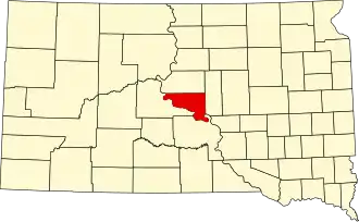
Hughes County is een van de 66 county's in de Amerikaanse staat South Dakota.
De county heeft een landoppervlakte van 1.919 km² en telt 16.481 inwoners (volkstelling 2000). De hoofdplaats is de stad Pierre, die tevens de hoofdstad van South Dakota is.
Bevolkingsontwikkeling
| Jaar | Inwoners | % ± | |
|---|---|---|---|
| 1900 | 3.684 | — | |
| 1910 | 6.271 | 70,2% | |
| 1920 | 5.711 | −8,9% | |
| 1930 | 7.009 | 22,7% | |
| 1940 | 6.624 | −5,5% | |
| 1950 | 8.111 | 22,4% | |
| 1960 | 12.725 | 56,9% | |
| 1970 | 11.632 | −8,6% | |
| 1980 | 14.220 | 22,2% | |
| 1990 | 14.817 | 4,2% | |
| 2000 | 16.481 | 11,2% | |
| Bron: (en) Historical Decennial Census Population | |||