Brule County
| County in de Verenigde Staten | |||
|---|---|---|---|
| |||
| Situering | |||
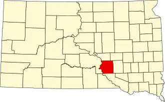
| Staat | South Dakota | ||
| Coördinaten | 43°43'12"NB, 99°3'36"WL | ||
| Algemeen | |||
| Oppervlakte | 2.192 km² | ||
| - land | 2.121 km² | ||
| - water | 71 km² | ||
| Inwoners (2000) |
5.364 (3 inw./km²) | ||
| Overig | |||
| Zetel | Chamberlain | ||
| FIPS-code | 46015 | ||
| Website | www | ||
| Foto's | |||
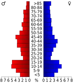 Bevolkingspiramide Brule County | |||
| Statistieken volkstelling Brule County | |||
| |||
Brule County is een van de 66 county's in de Amerikaanse staat South Dakota.
De county heeft een landoppervlakte van 2.121 km² en telt 5.364 inwoners (volkstelling 2000). De hoofdplaats is Chamberlain.
Bevolkingsontwikkeling
| Jaar | Inwoners | % ± | |
|---|---|---|---|
| 1900 | 5.401 | — | |
| 1910 | 6.451 | 19,4% | |
| 1920 | 7.141 | 10,7% | |
| 1930 | 7.416 | 3,9% | |
| 1940 | 6.195 | −16,5% | |
| 1950 | 6.076 | −1,9% | |
| 1960 | 6.319 | 4,0% | |
| 1970 | 5.870 | −7,1% | |
| 1980 | 5.245 | −10,6% | |
| 1990 | 5.485 | 4,6% | |
| 2000 | 5.364 | −2,2% | |
| Bron: (en) Historical Decennial Census Population | |||