Brown County (South Dakota)
| County in de Verenigde Staten | |||
|---|---|---|---|
| |||
| Situering | |||
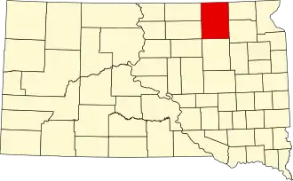
| Staat | South Dakota | ||
| Coördinaten | 45°36'NB, 98°21'WL | ||
| Algemeen | |||
| Oppervlakte | 4.484 km² | ||
| - land | 4.437 km² | ||
| - water | 47 km² | ||
| Inwoners (2000) |
35.460 (8 inw./km²) | ||
| Overig | |||
| Zetel | Aberdeen (South Dakota) | ||
| FIPS-code | 46013 | ||
| Website | www | ||
| Foto's | |||
_-_restored.jpg)
| |||
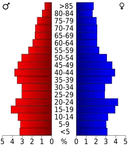 Bevolkingspiramide Brown County | |||
| Statistieken volkstelling Brown County | |||
| |||
Brown County is een van de 66 county's in de Amerikaanse staat South Dakota.
De county heeft een landoppervlakte van 4.437 km² en telt 35.460 inwoners (volkstelling 2000). De hoofdplaats is Aberdeen (South Dakota).
Bevolkingsontwikkeling
| Jaar | Inwoners | % ± | |
|---|---|---|---|
| 1900 | 15.286 | — | |
| 1910 | 25.867 | 69,2% | |
| 1920 | 29.509 | 14,1% | |
| 1930 | 31.458 | 6,6% | |
| 1940 | 29.676 | −5,7% | |
| 1950 | 32.617 | 9,9% | |
| 1960 | 34.106 | 4,6% | |
| 1970 | 36.920 | 8,3% | |
| 1980 | 36.962 | 0,1% | |
| 1990 | 35.580 | −3,7% | |
| 2000 | 35.460 | −0,3% | |
| Bron: (en) Historical Decennial Census Population | |||