Hand County
| County in de Verenigde Staten | |||
|---|---|---|---|

| |||
| Situering | |||
| Staat | South Dakota | ||
| Coördinaten | 44°33'NB, 99°0'WL | ||
| Algemeen | |||
| Oppervlakte | 3.730 km² | ||
| - land | 3.721 km² | ||
| - water | 9 km² | ||
| Inwoners (2000) |
3.741 (1 inw./km²) | ||
| Overig | |||
| Zetel | Miller | ||
| FIPS-code | 46059 | ||
| Website | hand | ||
| Foto's | |||
.png)
| |||
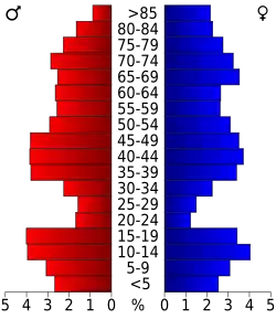 Bevolkingspiramide Hand County | |||
| Statistieken volkstelling Hand County | |||
| |||
Hand County is een van de 66 county's in de Amerikaanse staat South Dakota.
De county heeft een landoppervlakte van 3.721 km² en telt 3.741 inwoners (volkstelling 2000). De hoofdplaats is Miller.
Bevolkingsontwikkeling
| Jaar | Inwoners | % ± | |
|---|---|---|---|
| 1900 | 4.525 | — | |
| 1910 | 7.870 | 73,9% | |
| 1920 | 8.778 | 11,5% | |
| 1930 | 9.485 | 8,1% | |
| 1940 | 7.166 | −24,4% | |
| 1950 | 7.149 | −0,2% | |
| 1960 | 6.712 | −6,1% | |
| 1970 | 5.883 | −12,4% | |
| 1980 | 4.948 | −15,9% | |
| 1990 | 4.272 | −13,7% | |
| 2000 | 3.741 | −12,4% | |
| Bron: (en) Historical Decennial Census Population | |||