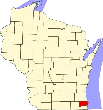
Racine County
| County in de Verenigde Staten | |||
|---|---|---|---|
| |||
| Situering | |||
| Staat | Wisconsin | ||
| Tijdzone | Central Standard Time (UTC−6) | ||
| Coördinaten | 42°46'48"NB, 87°45'36"WL | ||
| Algemeen | |||
| Oppervlakte | 2.051 km² | ||
| - land | 863 km² | ||
| - water | 1.188 km² | ||
| Inwoners (2000) |
188.831 (219 inw./km²) | ||
| Overig | |||
| Zetel | Racine | ||
| FIPS-code | 55101 | ||
| Opgericht | 1836 | ||
| Website | www | ||
| Foto's | |||
| |||
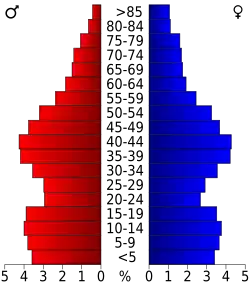 Bevolkingspiramide Racine County | |||
| Statistieken volkstelling Racine County | |||
| |||
Racine County is een van de 72 county's in de Amerikaanse staat Wisconsin.
De county heeft een landoppervlakte van 863 km² en telt 188.831 inwoners (volkstelling 2000). De hoofdplaats is Racine.
Bevolkingsontwikkeling
| Jaar | Inwoners | % ± | |
|---|---|---|---|
| 1900 | 45.644 | — | |
| 1910 | 57.424 | 25,8% | |
| 1920 | 78.961 | 37,5% | |
| 1930 | 90.217 | 14,3% | |
| 1940 | 94.047 | 4,2% | |
| 1950 | 109.585 | 16,5% | |
| 1960 | 141.781 | 29,4% | |
| 1970 | 170.838 | 20,5% | |
| 1980 | 173.132 | 1,3% | |
| 1990 | 175.034 | 1,1% | |
| 2000 | 188.831 | 7,9% | |
| Bron: (en) Historical Decennial Census Population | |||