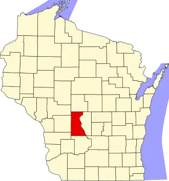
Juneau County
| County in de Verenigde Staten | |||
|---|---|---|---|
| |||
| Situering | |||
| Staat | Wisconsin | ||
| Tijdzone | Central Standard Time (UTC−6) | ||
| Coördinaten | 43°55'12"NB, 90°6'36"WL | ||
| Algemeen | |||
| Oppervlakte | 2.083 km² | ||
| - land | 1.988 km² | ||
| - water | 95 km² | ||
| Inwoners (2000) |
24.316 (12 inw./km²) | ||
| Overig | |||
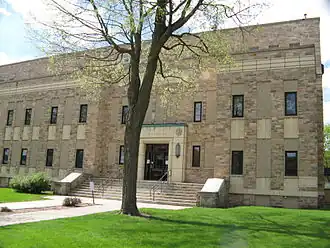
| Zetel | Mauston | ||
| FIPS-code | 55057 | ||
| Opgericht | 1856 | ||
| Website | www | ||
| Foto's | |||
| |||
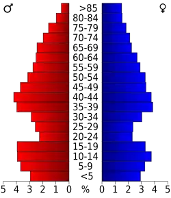 Bevolkingspiramide Juneau County | |||
| Statistieken volkstelling Juneau County | |||
| |||
Juneau County is een van de 72 county's in de Amerikaanse staat Wisconsin.
De county heeft een landoppervlakte van 1.988 km² en telt 24.316 inwoners (volkstelling 2000). De hoofdplaats is Mauston.
Bevolkingsontwikkeling
| Jaar | Inwoners | % ± | |
|---|---|---|---|
| 1900 | 20.629 | — | |
| 1910 | 19.569 | −5,1% | |
| 1920 | 19.209 | −1,8% | |
| 1930 | 17.264 | −10,1% | |
| 1940 | 18.708 | 8,4% | |
| 1950 | 18.930 | 1,2% | |
| 1960 | 17.490 | −7,6% | |
| 1970 | 18.455 | 5,5% | |
| 1980 | 21.039 | 14,0% | |
| 1990 | 21.650 | 2,9% | |
| 2000 | 24.316 | 12,3% | |
| Bron: (en) Historical Decennial Census Population | |||
Externe link
Zie de categorie Juneau County, Wisconsin van Wikimedia Commons voor mediabestanden over dit onderwerp.