Barron County
| County in de Verenigde Staten | |||
|---|---|---|---|
| |||
| Situering | |||
| Staat | Wisconsin | ||
| Tijdzone | Central Standard Time (UTC−6) | ||
| Coördinaten | 45°25'12"NB, 91°51'0"WL | ||
| Algemeen | |||
| Oppervlakte | 2.305 km² | ||
| - land | 2.235 km² | ||
| - water | 70 km² | ||
| Inwoners (2000) |
44.963 (20 inw./km²) | ||
| Overig | |||
| Zetel | Barron | ||
| FIPS-code | 55005 | ||
| Opgericht | 1859 | ||
| Website | www | ||
| Foto's | |||
| |||
 Bevolkingspiramide Barron County | |||
| Statistieken volkstelling Barron County | |||
| |||
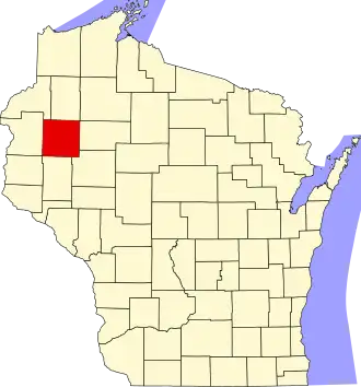
Barron County is een van de 72 county's in de Amerikaanse staat Wisconsin.
De county heeft een landoppervlakte van 2.235 km² en telt 44.963 inwoners (volkstelling 2000). De hoofdplaats is Barron.
Bevolkingsontwikkeling
| Jaar | Inwoners | % ± | |
|---|---|---|---|
| 1900 | 23.677 | — | |
| 1910 | 29.114 | 23,0% | |
| 1920 | 34.281 | 17,7% | |
| 1930 | 34.301 | 0,1% | |
| 1940 | 34.289 | −0,0% | |
| 1950 | 34.703 | 1,2% | |
| 1960 | 34.270 | −1,2% | |
| 1970 | 33.955 | −0,9% | |
| 1980 | 38.730 | 14,1% | |
| 1990 | 40.750 | 5,2% | |
| 2000 | 44.963 | 10,3% | |
| Bron: (en) Historical Decennial Census Population | |||