Carroll County (Iowa)
| County in de Verenigde Staten | |||
|---|---|---|---|
| |||
| Situering | |||
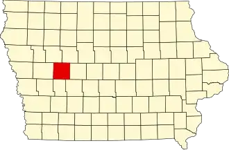
| Staat | Iowa | ||
| Coördinaten | 42°2'14"NB, 94°51'32"WL | ||
| Algemeen | |||
| Oppervlakte | 1.477 km² | ||
| - land | 1.475 km² | ||
| - water | 2 km² | ||
| Inwoners (2000) |
21.421 (15 inw./km²) | ||
| Overig | |||
| Zetel | Carroll | ||
| FIPS-code | 19027 | ||
| Opgericht | 1851 | ||
| Website | www | ||
| Foto's | |||

| |||
 Bevolkingspiramide Carroll County | |||
| Statistieken volkstelling Carroll County | |||
| |||
Carroll County is een county in de Amerikaanse staat Iowa.
De county heeft een landoppervlakte van 1.475 km² en telt 21.421 inwoners (volkstelling 2000). De hoofdplaats is Carroll.
Bevolkingsontwikkeling
| Jaar | Inwoners | % ± | |
|---|---|---|---|
| 1900 | 20.319 | — | |
| 1910 | 20.117 | −1,0% | |
| 1920 | 21.549 | 7,1% | |
| 1930 | 22.326 | 3,6% | |
| 1940 | 22.770 | 2,0% | |
| 1950 | 23.065 | 1,3% | |
| 1960 | 23.431 | 1,6% | |
| 1970 | 22.912 | −2,2% | |
| 1980 | 22.951 | 0,2% | |
| 1990 | 21.423 | −6,7% | |
| 2000 | 21.421 | −0,0% | |
| Bron: (en) Historical Decennial Census Population | |||