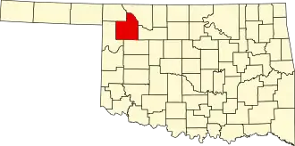
Woodward County
| County in de Verenigde Staten | |||
|---|---|---|---|
| |||
| Situering | |||
| Staat | Oklahoma | ||
| Tijdzone | Central Standard Time (UTC−6) | ||
| Coördinaten | 36°25'12"NB, 99°15'36"WL | ||
| Algemeen | |||
| Oppervlakte | 3.228 km² | ||
| - land | 3.218 km² | ||
| - water | 10 km² | ||
| Inwoners (2000) |
18.486 (6 inw./km²) | ||
| Overig | |||
| Zetel | Woodward | ||
| FIPS-code | 40153 | ||
| Opgericht | 1893 | ||
| Website | woodwardcounty | ||
| Foto's | |||

| |||
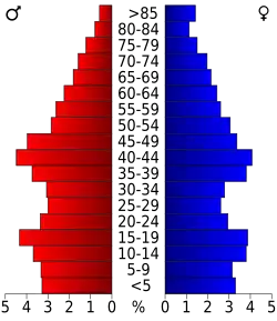 Bevolkingspiramide Woodward County | |||
| Statistieken volkstelling Woodward County | |||
| |||
Woodward County is een van de 77 county's in de Amerikaanse staat Oklahoma.
De county heeft een landoppervlakte van 3.218 km² en telt 18.486 inwoners (volkstelling 2000). De hoofdplaats is Woodward.
Bevolkingsontwikkeling
| Jaar | Inwoners | % ± | |
|---|---|---|---|
| 1900 | 7.469 | — | |
| 1910 | 16.592 | 122,1% | |
| 1920 | 14.663 | −11,6% | |
| 1930 | 15.844 | 8,1% | |
| 1940 | 16.270 | 2,7% | |
| 1950 | 14.383 | −11,6% | |
| 1960 | 13.902 | −3,3% | |
| 1970 | 15.537 | 11,8% | |
| 1980 | 21.172 | 36,3% | |
| 1990 | 18.976 | −10,4% | |
| 2000 | 18.486 | −2,6% | |
| Bron: (en) Historical Decennial Census Population | |||