Morpeth
| Civil parish in Engeland | |||
|---|---|---|---|
 | |||
| Situering | |||
| Regio | North East England | ||
| Graafschap | Northumberland | ||
| District | Northumberland | ||
| Coördinaten | 55° 10' NB, 1° 41' WL | ||
| Algemeen | |||
| Oppervlakte | 8,9734 km² | ||
| Inwoners (2011) |
14017 (1562 inw./km²) | ||
| Overig | |||
| Postcode(s) | NE61 | ||
| Netnummer(s) | 01670 | ||
| Grid code | NZ2085 | ||
| Post town | MORPETH | ||
| ONS-code | E04010834 | ||
| Website | www | ||
| Foto's | |||
| |||
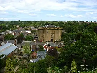
| Kasteel van Morpeth | |||
| |||
Morpeth is een civil parish in het Engelse graafschap Northumberland. Het is de hoofdstad van het graafschap. Morpeth telt 14.000 inwoners.
-
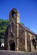 Morpeth Chantry
Geplaatst op:
26-12-2008
26-12-2008
Dit artikel is een beginnetje over landen & volken. U wordt uitgenodigd om op bewerken te klikken om uw kennis aan dit artikel toe te voegen.