Belford (Northumberland)
| Civil parish in Engeland | |||
|---|---|---|---|
 | |||
| Situering | |||
| Regio | North East England | ||
| Graafschap | Northumberland | ||
| District | Northumberland | ||
| Coördinaten | 55° 36' NB, 1° 50' WL | ||
| Algemeen | |||
| Oppervlakte | 21,1623 km² | ||
| Inwoners (2011) |
1258 (59 inw./km²) | ||
| Overig | |||
| Postcode(s) | NE70 | ||
| Netnummer(s) | 01668 | ||
| Grid code | NU108339 | ||
| Post town | BELFORD | ||
| ONS-code | E04010741 | ||
| Foto's | |||
| |||
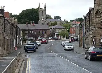
| High Street, Belford | |||
| |||
Belford is een civil parish in het bestuurlijke gebied Northumberland, in het Engelse graafschap Northumberland met 1258 inwoners.
Geplaatst op:
15-8-2010
15-8-2010
Dit artikel is een beginnetje over landen & volken. U wordt uitgenodigd om op bewerken te klikken om uw kennis aan dit artikel toe te voegen.