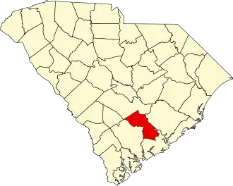
Dorchester County (South Carolina)
| County in de Verenigde Staten | |||
|---|---|---|---|
| |||
| Situering | |||
| Staat | South Carolina | ||
| Coördinaten | 33°4'48"NB, 80°24'0"WL | ||
| Algemeen | |||
| Oppervlakte | 1.494 km² | ||
| - land | 1.489 km² | ||
| - water | 5 km² | ||
| Inwoners (2000) |
96.413 (65 inw./km²) | ||
| Overig | |||
| Zetel | St. George | ||
| FIPS-code | 45035 | ||
| Opgericht | 1868 | ||
| Website | www | ||
| Foto's | |||
| |||
 Bevolkingspiramide Dorchester County | |||
| Statistieken volkstelling Dorchester County | |||
| |||
Dorchester County is een van de 46 county's in de Amerikaanse staat South Carolina.
De county heeft een landoppervlakte van 1.489 km² en telt 96.413 inwoners (volkstelling 2000). De hoofdplaats is St. George.
Bevolkingsontwikkeling
| Jaar | Inwoners | % ± | |
|---|---|---|---|
| 1900 | 16.294 | — | |
| 1910 | 17.891 | 9,8% | |
| 1920 | 19.459 | 8,8% | |
| 1930 | 18.956 | −2,6% | |
| 1940 | 19.928 | 5,1% | |
| 1950 | 22.601 | 13,4% | |
| 1960 | 24.383 | 7,9% | |
| 1970 | 32.276 | 32,4% | |
| 1980 | 58.761 | 82,1% | |
| 1990 | 83.060 | 41,4% | |
| 2000 | 96.413 | 16,1% | |
| Bron: (en) Historical Decennial Census Population | |||