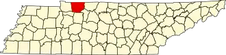
Montgomery County (Tennessee)
| County in de Verenigde Staten | |||
|---|---|---|---|
| |||
| Situering | |||
| Staat | Tennessee | ||
| Coördinaten | 36°30'0"NB, 87°22'48"WL | ||
| Algemeen | |||
| Oppervlakte | 1.409 km² | ||
| - land | 1.397 km² | ||
| - water | 12 km² | ||
| Inwoners (2000) |
134.768 (96 inw./km²) | ||
| Overig | |||
| Zetel | Clarksville | ||
| FIPS-code | 47125 | ||
| Opgericht | 1796 | ||
| Website | mcgtn | ||
| Foto's | |||

| |||
 Bevolkingspiramide Montgomery County | |||
| Statistieken volkstelling Montgomery County | |||
| |||
Montgomery County is een van de 95 county's in de Amerikaanse staat Tennessee.
De county heeft een landoppervlakte van 1.397 km² en telt 134.768 inwoners (volkstelling 2000). De hoofdplaats is Clarksville.
Bevolkingsontwikkeling
| Jaar | Inwoners | % ± | |
|---|---|---|---|
| 1900 | 36.017 | — | |
| 1910 | 33.672 | −6,5% | |
| 1920 | 32.265 | −4,2% | |
| 1930 | 30.882 | −4,3% | |
| 1940 | 33.346 | 8,0% | |
| 1950 | 44.186 | 32,5% | |
| 1960 | 55.645 | 25,9% | |
| 1970 | 62.721 | 12,7% | |
| 1980 | 83.342 | 32,9% | |
| 1990 | 100.498 | 20,6% | |
| 2000 | 134.768 | 34,1% | |
| Bron: (en) Historical Decennial Census Population | |||