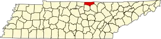
Clay County (Tennessee)
| County in de Verenigde Staten | |||
|---|---|---|---|
| |||
| Situering | |||
| Staat | Tennessee | ||
| Coördinaten | 36°33'0"NB, 85°32'24"WL | ||
| Algemeen | |||
| Oppervlakte | 672 km² | ||
| - land | 612 km² | ||
| - water | 60 km² | ||
| Inwoners (2000) |
7.976 (13 inw./km²) | ||
| Overig | |||
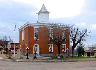
| Zetel | Celina | ||
| FIPS-code | 47027 | ||
| Opgericht | 1870 | ||
| Website | dalehollowlake | ||
| Foto's | |||
| |||
 Bevolkingspiramide Clay County | |||
| Statistieken volkstelling Clay County | |||
| |||
Clay County is een van de 95 county's in de Amerikaanse staat Tennessee.
De county heeft een landoppervlakte van 612 km² en telt 7.976 inwoners (volkstelling 2000). De hoofdplaats is Celina.
Bevolkingsontwikkeling
| Jaar | Inwoners | % ± | |
|---|---|---|---|
| 1900 | 8.421 | — | |
| 1910 | 9.009 | 7,0% | |
| 1920 | 9.193 | 2,0% | |
| 1930 | 9.577 | 4,2% | |
| 1940 | 10.904 | 13,9% | |
| 1950 | 8.701 | −20,2% | |
| 1960 | 7.289 | −16,2% | |
| 1970 | 6.624 | −9,1% | |
| 1980 | 7.676 | 15,9% | |
| 1990 | 7.238 | −5,7% | |
| 2000 | 7.976 | 10,2% | |
| Bron: (en) Historical Decennial Census Population | |||