Whatcom County
| County in de Verenigde Staten | |||
|---|---|---|---|

| |||
| Situering | |||
| Staat | Washington | ||
| Tijdzone | Pacific Standard Time (UTC−8) | ||
| Coördinaten | 48°49'48"NB, 121°54'0"WL | ||
| Algemeen | |||
| Oppervlakte | 6.485 km² | ||
| - land | 5.490 km² | ||
| - water | 995 km² | ||
| Inwoners (2000) |
166.814 (30 inw./km²) | ||
| Overig | |||
| Zetel | Bellingham (Washington) | ||
| FIPS-code | 53073 | ||
| Opgericht | 1854 | ||
| Website | www | ||
| Foto's | |||

| |||
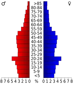 Bevolkingspiramide Whatcom County | |||
| Statistieken volkstelling Whatcom County | |||
| |||
Whatcom County is een van de 39 county's in de Amerikaanse staat Washington.
De county heeft een landoppervlakte van 5.490 km² en telt 166.814 inwoners (volkstelling 2000). De hoofdplaats is Bellingham (Washington).
Whatcom County grenst in het noorden aan Canada, met name aan onder meer de gemeenten Langley en Abbotsford.
Bevolkingsontwikkeling
| Jaar | Inwoners | % ± | |
|---|---|---|---|
| 1900 | 24.116 | — | |
| 1910 | 49.511 | 105,3% | |
| 1920 | 50.600 | 2,2% | |
| 1930 | 59.128 | 16,9% | |
| 1940 | 60.355 | 2,1% | |
| 1950 | 66.733 | 10,6% | |
| 1960 | 70.317 | 5,4% | |
| 1970 | 81.950 | 16,5% | |
| 1980 | 106.701 | 30,2% | |
| 1990 | 127.780 | 19,8% | |
| 2000 | 166.814 | 30,5% | |
| Bron: (en) Historical Decennial Census Population | |||
Zie de categorie Whatcom County, Washington van Wikimedia Commons voor mediabestanden over dit onderwerp.