Wahkiakum County
| County in de Verenigde Staten | |||
|---|---|---|---|
| |||
| Situering | |||
| Staat | Washington | ||
| Tijdzone | Pacific Standard Time (UTC−8) | ||
| Coördinaten | 46°17'24"NB, 123°25'48"WL | ||
| Algemeen | |||
| Oppervlakte | 742 km² | ||
| - land | 684 km² | ||
| - water | 58 km² | ||
| Inwoners (2000) |
3.824 (6 inw./km²) | ||
| Overig | |||
| Zetel | Cathlamet | ||
| FIPS-code | 53069 | ||
| Opgericht | 1954 | ||
| Website | www | ||
| Foto's | |||

| |||
 Bevolkingspiramide Wahkiakum County | |||
| Statistieken volkstelling Wahkiakum County | |||
| |||
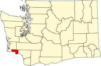
Wahkiakum County is een van de 39 county's in de Amerikaanse staat Washington.
De county heeft een landoppervlakte van 684 km² en telt 3.824 inwoners (volkstelling 2000). De hoofdplaats is Cathlamet.
Bevolkingsontwikkeling
| Jaar | Inwoners | % ± | |
|---|---|---|---|
| 1900 | 2.819 | — | |
| 1910 | 3.285 | 16,5% | |
| 1920 | 3.472 | 5,7% | |
| 1930 | 3.862 | 11,2% | |
| 1940 | 4.286 | 11,0% | |
| 1950 | 3.835 | −10,5% | |
| 1960 | 3.426 | −10,7% | |
| 1970 | 3.592 | 4,8% | |
| 1980 | 3.832 | 6,7% | |
| 1990 | 3.327 | −13,2% | |
| 2000 | 3.824 | 14,9% | |
| Bron: (en) Historical Decennial Census Population | |||
Zie de categorie Wahkiakum County, Washington van Wikimedia Commons voor mediabestanden over dit onderwerp.