Columbia County (Washington)
| County in de Verenigde Staten | |||
|---|---|---|---|
| |||
| Situering | |||
| Staat | Washington | ||
| Tijdzone | Pacific Standard Time (UTC−8) | ||
| Coördinaten | 46°18'0"NB, 117°55'12"WL | ||
| Algemeen | |||
| Oppervlakte | 2.262 km² | ||
| - land | 2.250 km² | ||
| - water | 12 km² | ||
| Inwoners (2000) |
4.064 (2 inw./km²) | ||
| Overig | |||
| Zetel | Dayton | ||
| FIPS-code | 53013 | ||
| Opgericht | 1875 | ||
| Website | www | ||
| Foto's | |||

| |||
 Bevolkingspiramide Columbia County | |||
| Statistieken volkstelling Columbia County | |||
| |||
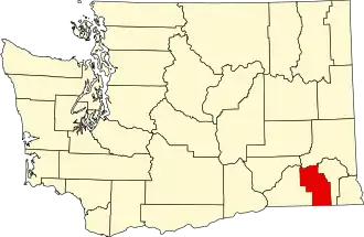
Columbia County is een van de 39 county's in de Amerikaanse staat Washington.
De county heeft een landoppervlakte van 2.250 km² en telt 4.064 inwoners (volkstelling 2000). De hoofdplaats is Dayton.
Bevolkingsontwikkeling
| Jaar | Inwoners | % ± | |
|---|---|---|---|
| 1900 | 7.128 | — | |
| 1910 | 7.042 | −1,2% | |
| 1920 | 6.093 | −13,5% | |
| 1930 | 5.325 | −12,6% | |
| 1940 | 5.549 | 4,2% | |
| 1950 | 4.860 | −12,4% | |
| 1960 | 4.569 | −6,0% | |
| 1970 | 4.439 | −2,8% | |
| 1980 | 4.057 | −8,6% | |
| 1990 | 4.024 | −0,8% | |
| 2000 | 4.064 | 1,0% | |
| 2020 | 3.952 | — | |
| Bron: (en) Historical Decennial Census Population | |||

Plaatsen in Columbia County
Zie de categorie Columbia County, Washington van Wikimedia Commons voor mediabestanden over dit onderwerp.