Watauga County
| County in de Verenigde Staten | |||
|---|---|---|---|
| |||
| Situering | |||
| Staat | North Carolina | ||
| Tijdzone | Eastern Standard Time (UTC−5) | ||
| Coördinaten | 36°13'48"NB, 81°42'0"WL | ||
| Algemeen | |||
| Oppervlakte | 810 km² | ||
| - land | 809 km² | ||
| - water | 1 km² | ||
| Inwoners (2000) |
42.695 (53 inw./km²) | ||
| Overig | |||
| Zetel | Boone | ||
| FIPS-code | 37189 | ||
| Opgericht | 1849 | ||
| Website | www | ||
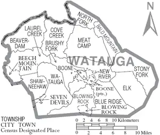
| Detailkaart | |||
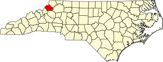
| |||
| Overzichtskaart van Watauga County | |||
| Foto's | |||

| |||
 Bevolkingspiramide Watauga County | |||
| Statistieken volkstelling Watauga County | |||
| |||
Watauga County is een county in de Amerikaanse staat North Carolina.
De county heeft een landoppervlakte van 809 km² en telt 42.695 inwoners (volkstelling 2000). De hoofdplaats is Boone.
Bevolkingsontwikkeling
| Jaar | Inwoners | % ± | |
|---|---|---|---|
| 1900 | 13.417 | — | |
| 1910 | 13.556 | 1,0% | |
| 1920 | 13.477 | −0,6% | |
| 1930 | 15.165 | 12,5% | |
| 1940 | 18.114 | 19,4% | |
| 1950 | 18.342 | 1,3% | |
| 1960 | 17.529 | −4,4% | |
| 1970 | 23.404 | 33,5% | |
| 1980 | 31.666 | 35,3% | |
| 1990 | 36.952 | 16,7% | |
| 2000 | 42.695 | 15,5% | |
| Bron: (en) Historical Decennial Census Population | |||