Rutherford County (North Carolina)
| County in de Verenigde Staten | |||
|---|---|---|---|

| |||
| Situering | |||
| Staat | North Carolina | ||
| Tijdzone | Eastern Standard Time (UTC−5) | ||
| Coördinaten | 35°24'0"NB, 81°55'12"WL | ||
| Algemeen | |||
| Oppervlakte | 1.466 km² | ||
| - land | 1.461 km² | ||
| - water | 5 km² | ||
| Inwoners (2000) |
62.899 (43 inw./km²) | ||
| Overig | |||
| Zetel | Rutherfordton | ||
| FIPS-code | 37161 | ||
| Opgericht | 1779 | ||
| Website | rutherfordcountync | ||
| Foto's | |||

| |||
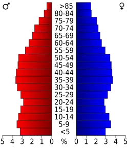 Bevolkingspiramide Rutherford County | |||
| Statistieken volkstelling Rutherford County | |||
| |||
Rutherford County is een county in de Amerikaanse staat North Carolina.
De county heeft een landoppervlakte van 1.461 km² en telt 62.899 inwoners (volkstelling 2000). De hoofdplaats is Rutherfordton.
Bevolkingsontwikkeling
| Jaar | Inwoners | % ± | |
|---|---|---|---|
| 1900 | 25.101 | — | |
| 1910 | 28.385 | 13,1% | |
| 1920 | 31.426 | 10,7% | |
| 1930 | 40.452 | 28,7% | |
| 1940 | 45.577 | 12,7% | |
| 1950 | 46.356 | 1,7% | |
| 1960 | 45.091 | −2,7% | |
| 1970 | 47.337 | 5,0% | |
| 1980 | 53.787 | 13,6% | |
| 1990 | 56.918 | 5,8% | |
| 2000 | 62.899 | 10,5% | |
| Bron: (en) Historical Decennial Census Population | |||