Pamlico County
| County in de Verenigde Staten | |||
|---|---|---|---|

| |||
| Situering | |||
| Staat | North Carolina | ||
| Tijdzone | Eastern Standard Time (UTC−5) | ||
| Coördinaten | 35°9'0"NB, 76°40'12"WL | ||
| Algemeen | |||
| Oppervlakte | 1.467 km² | ||
| - land | 873 km² | ||
| - water | 594 km² | ||
| Inwoners (2000) |
12.934 (15 inw./km²) | ||
| Overig | |||
| Zetel | Bayboro | ||
| FIPS-code | 37137 | ||
| Opgericht | 1872 | ||
| Website | www | ||
| Detailkaart | |||
| |||
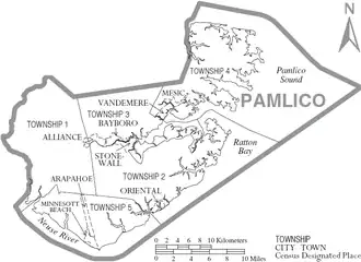
| Overzichtskaart van Pamlico County | |||
| Foto's | |||

| |||
 Bevolkingspiramide Pamlico County | |||
| Statistieken volkstelling Pamlico County | |||
| |||
Pamlico County is een county in de Amerikaanse staat North Carolina.
De county heeft een landoppervlakte van 873 km² en telt 12.934 inwoners (volkstelling 2000). De hoofdplaats is Bayboro.
Bevolkingsontwikkeling
| Jaar | Inwoners | % ± | |
|---|---|---|---|
| 1900 | 8.045 | — | |
| 1910 | 9.966 | 23,9% | |
| 1920 | 9.060 | −9,1% | |
| 1930 | 9.299 | 2,6% | |
| 1940 | 9.706 | 4,4% | |
| 1950 | 9.993 | 3,0% | |
| 1960 | 9.850 | −1,4% | |
| 1970 | 9.467 | −3,9% | |
| 1980 | 10.398 | 9,8% | |
| 1990 | 11.372 | 9,4% | |
| 2000 | 12.934 | 13,7% | |
| Bron: (en) Historical Decennial Census Population | |||