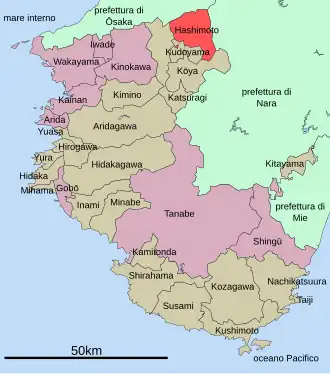
Hashimoto
| Plaats in Japan | |||
|---|---|---|---|
 | |||
| Situering | |||
| Eiland | Honshu | ||
| Regio | Kansai | ||
| Prefectuur | |||
| Coördinaten | 34° 18′ NB, 135° 36′ OL | ||
| Algemeen | |||
| Oppervlakte | 130,31 km² | ||
| Inwoners | 67.494 | ||
| Datum | 1 maart 2008 | ||
| Bevolkingsdichtheid | 518 inw./km2 | ||
| Gemeentenummer | 30203-1 | ||
| Gemeentehuis | |||
| Burgemeester | Kinoshita Yoshiyuki (木下善之) | ||
| Adres | 1-1-1, Tōge, Hashimoto-shi | ||
| Postcode | 〒648-8585 | ||
| Symbolen | |||
| Boom | Osmanthus | ||
| Bloem | Rhododendron indicum | ||
| Website | www | ||
| Detailkaart | |||
| |||
| ■:seirei shi / ■:shi / ■:cho·mura | |||
| |||
Hashimoto (橋本市,Hashimoto-shi) is een stad in de prefectuur Wakayama.
Op 1 maart 2008 had de stad 67.494 inwoners. De bevolkingsdichtheid bedraagt 518 km². De oppervlakte van de stad is 130,24 km². Hashimoto werd gesticht op 1 januari 1955.
Fusies
Op 1 maart 2006 werd de gemeente Koyaguchi van het District Ito opgeslorpt door de stad Hashimoto.
Verkeer
Externe link
- (ja) Officiële website