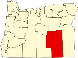
Harney County
| County in de Verenigde Staten | |||
|---|---|---|---|
| |||
| Situering | |||
| Staat | Oregon | ||
| Tijdzone | Mountain Standard Time (UTC−7) | ||
| Coördinaten | 43°4'12"NB, 118°58'12"WL | ||
| Algemeen | |||
| Oppervlakte | 26.487 km² | ||
| - land | 26.248 km² | ||
| - water | 239 km² | ||
| Inwoners (2000) |
7.609 (0 inw./km²) | ||
| Overig | |||
| Zetel | Burns (Oregon) | ||
| FIPS-code | 41025 | ||
| Opgericht | 1889 | ||
| Website | harneycountyor | ||
| Foto's | |||

| |||
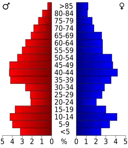 Bevolkingspiramide Harney County | |||
| Statistieken volkstelling Harney County | |||
| |||
Harney County is een van de 36 county's in de Amerikaanse staat Oregon.
De county heeft een landoppervlakte van 26.248 km² en telt 7.609 inwoners (volkstelling 2000). De hoofdplaats is Burns (Oregon).
Bevolkingsontwikkeling
| Jaar | Inwoners | % ± | |
|---|---|---|---|
| 1900 | 2.598 | — | |
| 1910 | 4.059 | 56,2% | |
| 1920 | 3.992 | −1,7% | |
| 1930 | 5.920 | 48,3% | |
| 1940 | 5.374 | −9,2% | |
| 1950 | 6.113 | 13,8% | |
| 1960 | 6.744 | 10,3% | |
| 1970 | 7.215 | 7,0% | |
| 1980 | 8.314 | 15,2% | |
| 1990 | 7.060 | −15,1% | |
| 2000 | 7.609 | 7,8% | |
| Bron: (en) Historical Decennial Census Population | |||
_(5773399075).jpg)