Yuma County (Colorado)
| County in de Verenigde Staten | |||
|---|---|---|---|

| |||
| Situering | |||
| Staat | Colorado | ||
| Coördinaten | 40°0'0"NB, 102°25'12"WL | ||
| Algemeen | |||
| Oppervlakte | 6.136 km² | ||
| - land | 6.127 km² | ||
| - water | 9 km² | ||
| Inwoners (2000) |
9.841 (2 inw./km²) | ||
| Overig | |||
| Zetel | Wray | ||
| FIPS-code | 08125 | ||
| Opgericht | 1889 | ||
| Website | www | ||
| Foto's | |||

| |||
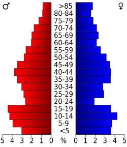 Bevolkingspiramide Yuma County | |||
| Statistieken volkstelling Yuma County | |||
| |||
Yuma County is een county in de Amerikaanse staat Colorado.
De county heeft een landoppervlakte van 6.127 km² en telt 9.841 inwoners (volkstelling 2000). De hoofdplaats is Wray.
Bevolkingsontwikkeling
| Jaar | Inwoners | % ± | |
|---|---|---|---|
| 1900 | 1.729 | — | |
| 1910 | 8.499 | 391,6% | |
| 1920 | 13.897 | 63,5% | |
| 1930 | 13.613 | −2,0% | |
| 1940 | 12.102 | −11,1% | |
| 1950 | 10.827 | −10,5% | |
| 1960 | 8.912 | −17,7% | |
| 1970 | 8.544 | −4,1% | |
| 1980 | 9.682 | 13,3% | |
| 1990 | 8.954 | −7,5% | |
| 2000 | 9.841 | 9,9% | |
| Bron: (en) Historical Decennial Census Population | |||
Zie de categorie Yuma County, Colorado van Wikimedia Commons voor mediabestanden over dit onderwerp.