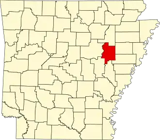
Woodruff County
| County in de Verenigde Staten | |||
|---|---|---|---|
| |||
| Situering | |||
| Staat | Arkansas | ||
| Coördinaten | 35°11'42"NB, 91°13'17"WL | ||
| Algemeen | |||
| Oppervlakte | 1.538 km² | ||
| - land | 1.519 km² | ||
| - water | 19 km² | ||
| Inwoners (2000) |
8.741 (6 inw./km²) | ||
| Overig | |||
| Zetel | Augusta | ||
| FIPS-code | 05147 | ||
| Opgericht | 1862 | ||
| Website | portal | ||
| Foto's | |||

| |||
 Bevolkingspiramide Woodruff County | |||
| Statistieken volkstelling Woodruff County | |||
| |||
Woodruff County is een county in de Amerikaanse staat Arkansas.
De county heeft een landoppervlakte van 1.519 km² en telt 8.741 inwoners (volkstelling 2000). De hoofdplaats is Augusta.
Bevolkingsontwikkeling
| Jaar | Inwoners | % ± | |
|---|---|---|---|
| 1900 | 16.304 | — | |
| 1910 | 20.049 | 23,0% | |
| 1920 | 21.547 | 7,5% | |
| 1930 | 22.682 | 5,3% | |
| 1940 | 22.133 | −2,4% | |
| 1950 | 18.957 | −14,3% | |
| 1960 | 13.954 | −26,4% | |
| 1970 | 11.566 | −17,1% | |
| 1980 | 11.222 | −3,0% | |
| 1990 | 9.520 | −15,2% | |
| 2000 | 8.741 | −8,2% | |
| Bron: (en) Historical Decennial Census Population | |||