Woodford County (Kentucky)
| County in de Verenigde Staten | |||
|---|---|---|---|
| |||
| Situering | |||
| Staat | Kentucky | ||
| Coördinaten | 38°2'24"NB, 84°44'24"WL | ||
| Algemeen | |||
| Oppervlakte | 497 km² | ||
| - land | 494 km² | ||
| - water | 3 km² | ||
| Inwoners (2000) |
23.208 (47 inw./km²) | ||
| Overig | |||
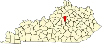
| Zetel | Versailles | ||
| FIPS-code | 21239 | ||
| Opgericht | 1788 | ||
| Website | woodfordcounty | ||
| Foto's | |||

| |||
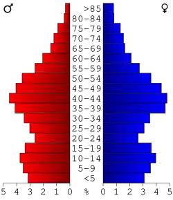 Bevolkingspiramide Woodford County | |||
| Statistieken volkstelling Woodford County | |||
| |||
Woodford County is een county in de Amerikaanse staat Kentucky.
De county heeft een landoppervlakte van 494 km² en telt 23.208 inwoners (volkstelling 2000). De hoofdplaats is Versailles.
Bevolkingsontwikkeling
| Jaar | Inwoners | % ± | |
|---|---|---|---|
| 1900 | 13.134 | — | |
| 1910 | 12.571 | −4,3% | |
| 1920 | 11.784 | −6,3% | |
| 1930 | 10.981 | −6,8% | |
| 1940 | 11.847 | 7,9% | |
| 1950 | 11.212 | −5,4% | |
| 1960 | 11.913 | 6,3% | |
| 1970 | 14.434 | 21,2% | |
| 1980 | 17.778 | 23,2% | |
| 1990 | 19.955 | 12,2% | |
| 2000 | 23.208 | 16,3% | |
| Bron: (en) Historical Decennial Census Population | |||
Geboren
- Charles W. Field (1828-1892), beroepsofficier en Zuidelijke generaal tijdens de Amerikaanse Burgeroorlog