Wollondilly Shire Council
| Local Government Area van Australië | |||
|---|---|---|---|
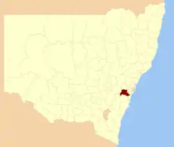 Locatie van Wollondilly Shire Council in New South Wales
| |||
| Situering | |||
| Staat | New South Wales | ||
| Streek | Southern Highlands, Central Tablelands | ||
| Hoofdplaats | Picton (62-64 Menangle Street)[1] | ||
| Coördinaten | 34°11'ZB, 150°36'OL | ||
| Algemene informatie | |||
| Oppervlakte | 2.560 km² | ||
| Inwoners | 38.424[2] | ||
| Politiek | |||
| Burgemeester | Phillip Costa | ||
| Overig | |||
| Website | http://www.wollondilly.nsw.gov.au | ||
| |||
Wollondilly Shire Council is een Local Government Area (LGA) in de Australische deelstaat New South Wales.
Bronnen, noten en/of referenties
- ↑ Wollondilly Shire Council. Department of Local Government. Gearchiveerd op 7 september 2006. Geraadpleegd op 27 november 2006.
- ↑ Wollondilly (A) (Local Government Area. 2001 Census QuickStats. Australian Bureau of Statistics. Geraadpleegd op 30 juni 2009.