Wicomico County
| County in de Verenigde Staten | |||
|---|---|---|---|
| |||
| Situering | |||
| Staat | Maryland | ||
| Coördinaten | 38°22'12"NB, 75°37'48"WL | ||
| Algemeen | |||
| Oppervlakte | 1.036 km² | ||
| - land | 977 km² | ||
| - water | 59 km² | ||
| Inwoners (2000) |
84.644 (87 inw./km²) | ||
| Overig | |||
| Zetel | Salisbury (Maryland) | ||
| FIPS-code | 24045 | ||
| Opgericht | 1867 | ||
| Website | www | ||
| Foto's | |||
_from_NW_1.JPG)
| |||
 Bevolkingspiramide Wicomico County | |||
| Statistieken volkstelling Wicomico County | |||
| |||
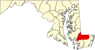
Wicomico County is een county in de Amerikaanse staat Maryland.
De county heeft een landoppervlakte van 977 km² en telt 84.644 inwoners (volkstelling 2000). De hoofdplaats is Salisbury (Maryland).
Bevolkingsontwikkeling
| Jaar | Inwoners | % ± | |
|---|---|---|---|
| 1900 | 22.852 | — | |
| 1910 | 26.815 | 17,3% | |
| 1920 | 28.165 | 5,0% | |
| 1930 | 31.229 | 10,9% | |
| 1940 | 34.530 | 10,6% | |
| 1950 | 39.641 | 14,8% | |
| 1960 | 49.050 | 23,7% | |
| 1970 | 54.236 | 10,6% | |
| 1980 | 64.540 | 19,0% | |
| 1990 | 74.339 | 15,2% | |
| 2000 | 84.644 | 13,9% | |
| Bron: (en) Historical Decennial Census Population | |||