Wichita County (Kansas)
| County in de Verenigde Staten | |||
|---|---|---|---|
| |||
| Situering | |||
| Staat | Kansas | ||
| Coördinaten | 38°28'0,1"NB, 101°21'0,0"WL | ||
| Algemeen | |||
| Oppervlakte | 1.861 km² | ||
| - land | 1.861 km² | ||
| - water | 0 km² | ||
| Inwoners (2000) |
2.531 (1 inw./km²) | ||
| Overig | |||
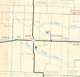
| Zetel | Leoti | ||
| FIPS-code | 20203 | ||
| Opgericht | 1873 | ||
| Website | www | ||
| Detailkaart | |||
| |||
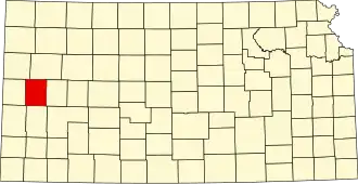
| Overzichtskaart van Wichita County | |||
| Foto's | |||
| |||
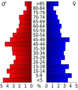 Bevolkingspiramide Wichita County | |||
| Statistieken volkstelling Wichita County | |||
| |||
Wichita County is een county in de Amerikaanse staat Kansas.
De county heeft een landoppervlakte van 1.861 km² en telt 2.531 inwoners (volkstelling 2000). De hoofdplaats is Leoti.
Bevolkingsontwikkeling
| Jaar | Inwoners | % ± | |
|---|---|---|---|
| 1900 | 1.197 | — | |
| 1910 | 2.006 | 67,6% | |
| 1920 | 1.856 | −7,5% | |
| 1930 | 2.579 | 39,0% | |
| 1940 | 2.185 | −15,3% | |
| 1950 | 2.640 | 20,8% | |
| 1960 | 2.765 | 4,7% | |
| 1970 | 3.274 | 18,4% | |
| 1980 | 3.041 | −7,1% | |
| 1990 | 2.758 | −9,3% | |
| 2000 | 2.531 | −8,2% | |
| Bron: (en) Historical Decennial Census Population | |||