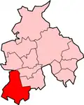
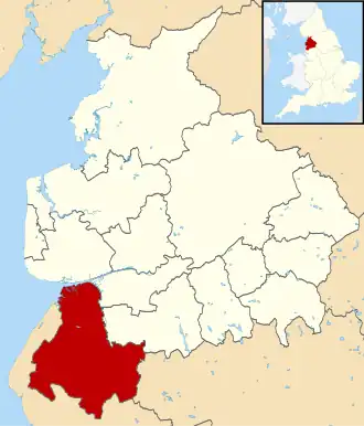
West Lancashire
| Niet-metropolitaans district in Engeland | |||
|---|---|---|---|
| |||
| Situering | |||
| Land | Engeland | ||
| County | Lancashire | ||
| Regio | North West England | ||
| Coördinaten | 53°33'43"NB, 2°49'37"WL | ||
| Algemeen | |||
| Oppervlakte | 346,7849[1] km² | ||
| Inwoners (2018[2]) |
113.949 (329 inw./km²) | ||
| ONS-code | E07000127 | ||
| Website | www | ||
| Detailkaart | |||
| |||
| |||
West Lancashire is een Engels district in het shire-graafschap (non-metropolitan county OF county) Lancashire en telt 114.000 inwoners. De oppervlakte bedraagt 347 km².
Van de bevolking is 15,6% ouder dan 65 jaar. De werkloosheid bedraagt 3,2% van de beroepsbevolking (cijfers volkstelling 2001).
Plaatsen in district West Lancashire
Civil parishes in district West Lancashire
Aughton, Bickerstaffe, Bispham, Burscough, Dalton, Downholland, Great Altcar, Halsall, Hesketh-with-Becconsall, Hilldale, Lathom, Lathom South, Newburgh, North Meols, Parbold, Rufford, Scarisbrick, Simonswood, Tarleton, Up Holland, Wrightington.
Bronnen, noten en/of referenties
- ↑ Office for National Statistics → Download → SAM_for_Administrative_Areas_(2018).zip → SAM_LAD_DEC_2018_UK.xlsx.
- ↑ https://www.ons.gov.uk/file?uri=/peoplepopulationandcommunity/populationandmigration/populationestimates/datasets/populationestimatesforukenglandandwalesscotlandandnorthernireland/mid20182019laboundaries/ukmidyearestimates20182019ladcodes.xls Schatting Office for National Statistics: knop MYE5 → kolom Estimated Population mid-2018]