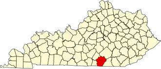
Wayne County (Kentucky)
| County in de Verenigde Staten | |||
|---|---|---|---|
| |||
| Situering | |||
| Staat | Kentucky | ||
| Coördinaten | 36°48'36"NB, 84°49'48"WL | ||
| Algemeen | |||
| Oppervlakte | 1.254 km² | ||
| - land | 1.190 km² | ||
| - water | 64 km² | ||
| Inwoners (2000) |
19.923 (17 inw./km²) | ||
| Overig | |||
| Zetel | Monticello | ||
| FIPS-code | 21231 | ||
| Opgericht | 1800 | ||
| Website | www | ||
| Foto's | |||

| |||
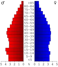 Bevolkingspiramide Wayne County | |||
| Statistieken volkstelling Wayne County | |||
| |||
Wayne County is een county in de Amerikaanse staat Kentucky.
De county heeft een landoppervlakte van 1.190 km² en telt 19.923 inwoners (volkstelling 2000). De hoofdplaats is Monticello.
Bevolkingsontwikkeling
| Jaar | Inwoners | % ± | |
|---|---|---|---|
| 1900 | 14.892 | — | |
| 1910 | 17.518 | 17,6% | |
| 1920 | 16.208 | −7,5% | |
| 1930 | 15.848 | −2,2% | |
| 1940 | 17.204 | 8,6% | |
| 1950 | 16.475 | −4,2% | |
| 1960 | 14.700 | −10,8% | |
| 1970 | 14.268 | −2,9% | |
| 1980 | 17.022 | 19,3% | |
| 1990 | 17.468 | 2,6% | |
| 2000 | 19.923 | 14,1% | |
| Bron: (en) Historical Decennial Census Population | |||