Wallace County
| County in de Verenigde Staten | |||
|---|---|---|---|

| |||
| Situering | |||
| Staat | Kansas | ||
| Coördinaten | 38°45'52"NB, 101°34'33"WL | ||
| Algemeen | |||
| Oppervlakte | 2.367 km² | ||
| - land | 2.367 km² | ||
| - water | 0 km² | ||
| Inwoners (2000) |
1.749 (1 inw./km²) | ||
| Overig | |||
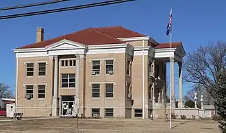
| Zetel | Sharon Springs | ||
| FIPS-code | 20199 | ||
| Opgericht | 1888 | ||
| Website | wallacecounty | ||
| Detailkaart | |||
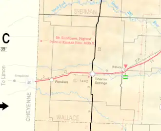
| |||
| Overzichtskaart van Wallace County | |||
| Foto's | |||
| |||
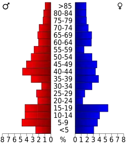 Bevolkingspiramide Wallace County | |||
| Statistieken volkstelling Wallace County | |||
| |||
Wallace County is een county in de Amerikaanse staat Kansas.
De county heeft een landoppervlakte van 2.367 km² en telt 1.749 inwoners (volkstelling 2000). De hoofdplaats is Sharon Springs. De county is genoemd naar William Hervey Lamme Wallace, generaal tijdens de Amerikaanse Burgeroorlog.
Bevolkingsontwikkeling
| Jaar | Inwoners | % ± | |
|---|---|---|---|
| 1900 | 1.178 | — | |
| 1910 | 2.759 | 134,2% | |
| 1920 | 2.424 | −12,1% | |
| 1930 | 2.882 | 18,9% | |
| 1940 | 2.216 | −23,1% | |
| 1950 | 2.508 | 13,2% | |
| 1960 | 2.069 | −17,5% | |
| 1970 | 2.215 | 7,1% | |
| 1980 | 2.045 | −7,7% | |
| 1990 | 1.821 | −11,0% | |
| 2000 | 1.749 | −4,0% | |
| Bron: (en) Historical Decennial Census Population | |||